Reefs (1170)
- Category: Habitat - surface monitoring
- Published: Tuesday, 15 November 2016 10:36
- Written by Super User
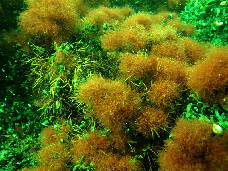
Reefs (1170) are defined as „underwater rocky substrate that arise from the sea floor, situated in sublittoral zone” (Warzocha 2004). Habitat is characterized by high taxonomic diversity of flora and fauna that is distributed in zones depending on depth. In the Polish marine areas, reefs are not rocky but stony, meaning they are formed by pebbles and boulders located in the littoral zone (Interpretation manual 2013). Species typical of habitat 1170 are macroalgae, mainly red algae Polysiphonia fucoides, strictly protected Furcellaria lumbricalis and Ceramium diaphanum (Regulation of the Minister of Environment on 9 Oct 2014 about the protection of plant species, Journal of Laws 2014 pos. 1409) and benthic invertebrates e.g. Mytilus trossulus and Gammarus (Warzocha 2004, Osowiecki and Kruk-Dowgiałło 2006 a, Osowiecki and Żmudziński 2000, Kruk-Dowgiałło et al. 2009, Kruk-Dowgiałło et al. 2011, SEM 2008-2015). So far, in the Polish marine areas only three sites belonging to habitat 1170 have been identified: Słupsk Bank – called “Słupsk Bank boulder area” (Warzocha 2014, SDF for PLC990001), near coastal Rowy locality – called „ Rowy boulder area” (SDF for PLH220023, Osowiecki and Kruk-Dowgiałło 2006 a) and in the Gulf of Gdańsk, nearby the Orłowo Cliff – natural rocky reefs (SDF for PLH220105, Osowiecki and Żmudziński 2000) and artificial reefs made of natural stones, so-called underwater breakwaters which were built in 2006 in order to protect the shore (Kruk-Dowgiałło et al. 2009).
Słupsk Bank boulder area is situated in the north-western part of the Słupsk Bank (site central point: 16°35,126’E; 54°58,271’N), at depth of 8-20 m, about 46 km northward from the coastal locality of Ustka.
Its surface area reaches 111.3 km and it covers 14% of the total area of Słupsk Bank Natura 2000 area (SDF for PLC990001). Bottom surface is specific and very diverse what makes the boulder area distinctive among all regions in the Southern Baltic.
Characteristic morphological features are chains of hills composed mostly of rock blocks and boulders, resistant to erosion (Kruk-Dowgiałło et al. 2011). Hard bottom and a relatively transparent water create favourable conditions for the development of different types of benthic communities with crucial species, so-called habitat-forming species e.g. Furcellaria lumbricalis, Ceramium diaphanum, Polysiphonia fucoides and Mytlius trossulus (Andrulewicz et al. 2004, Warzocha 2004, Kruk-Dowgiałło et al. 2011).

In many parts of the Słupsk Bank boulder area, species that are rare in the Polish marine waters can be observed, e.g. Coccotylus truncatus, Desmarestia viridis, Rhodomela confervoides as well as species rarely occurring in the Baltic Proper, e.g. Delesseria sanguinea (Kruk-Dowgiałło et al. 2011, SEM 2008-2015).
The Słupsk Bank boulder area has been a subject of scientific interests of marine biologists who used different research methods there (Demel and Mańkowski 1951, Demel and Mulicki 1954, Warzocha 1980, Okołotowicz 1991, Andrulewicz et al. 2004). The biggest area of this site (100 km) was examined in 2007. Using mapping method, habitats at level 3 and 5 of EUNIS classification were identified and for the first time natural values of this site have been assessed (Kruk-Dowgiałło et al. 2011). Since 2008, monitoring studies of phytobenthos has been carried out, within the framework of the State Environmental Monitoring programme in Poland. In 2016, environmental studies supported by the project ”Pilot monitoring studies of marine habitats and protected species in 2015-2018” were conducted in the boulder area. The results allowed status assessment of the site.
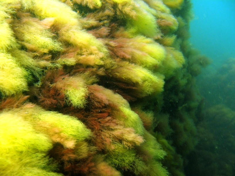
Rowy boulder area is situated in the middle coastal zone, at a depth between 2 and 18 m, approx. 1.5 km northward from Rowy locality (site central point: 17°02,810’E; 54°40,900’N). Rowy is located on both sides of the estuary of Łupawa River flowing through the Gardno Lake. Rowy boulder area is situated in the vicinity of the Słowiński National Park and it is protected under the Natura 2000 network in the form of PLH220023 Ostoja Słowińska and PLB990002 Coastal waters of the Baltic Sea (SDF for PLH220023). The site is formed by the abrasion platform with numerous stones and fields of boulders forming compacted abrasive pavement. Some of the boulders reach a diameter up to 4 m and extend above the bottom up to 2 m. Taxonomically diverse and highly abundant benthic communities with domination of macroalgae develop vastly on the stony bottom there. Mainly red algae such as Polysiphonia fucoides and Furcellaria lumbricalis occur, occasionally there are species rare for the Polish marine areas such as brown algae Sphacelaria cirrosa and protected red algae Ceramium tenuicorne (Osowiecki and Kruk-Dowgiałło 2006, Kruk-Dowgiałło et al. 2008, Brzeska 2009, SEM 2010-2015). Compared to other areas in the coastal zone of the Polish part of the Baltic Sea, macrozoobenthos observed in the Rowy boulder area should be considered as extremely rich in terms of taxonomic diversity and abundance. Occurrence of 23 species and unidentified individuals of Oligochaeta, Nemertinea and insect larvae were observed (Osowiecki and Kruk-Dowgiałło 2006 a).
Rowy boulder area was identified in 1996 during field studies aiming at valuation of marine protected areas (Kruk-Dowgiałło 2000). Further studies was designed to evaluate its biological diversity. Then, for the first time in the Polish marine areas, habitat mapping method was used. It based on the combined results of hydroacoustic (bathymetric and sonar maps) and biological research (Osowiecki and Kruk-Dowgiałło 2006 a, 2006 b, 2007). Since 2010, the monitoring studies of phytobenthos has been carried out in this area, within the framework of the State Environmental Monitoring programme in Poland. In 2016, environmental studies were conducted in the Rowy boulder area allowing its status assessment. Studies were supported by project ”Pilot monitoring studies of marine habitats and protected species in 2015-2018”.
Reefs in the Gulf of Gdańsk are located in the coastal zone nearby Orłowo Cliff which is protected under natural reserve Kępa Redłowska in Gdynia. As a result of high waves activity, the erosion is observed not only on cliff but also on the coastal strip of the seabed. It is an extremely dynamic and diverse area, where on the sandy bottom numerous pebbles and boulders, and even outcrops of lignite occur (Osowiecki and Żmudziński 2000). Area nearby the Orłowo Cliff is protected within Natura 2000 network as Orłowo cliffs and reefs PLH220105 (SDF for PLH220105) and Puck Bay PLB220005. According to the SDF for PLH220105 area, the habitat covers 78.29 ha.
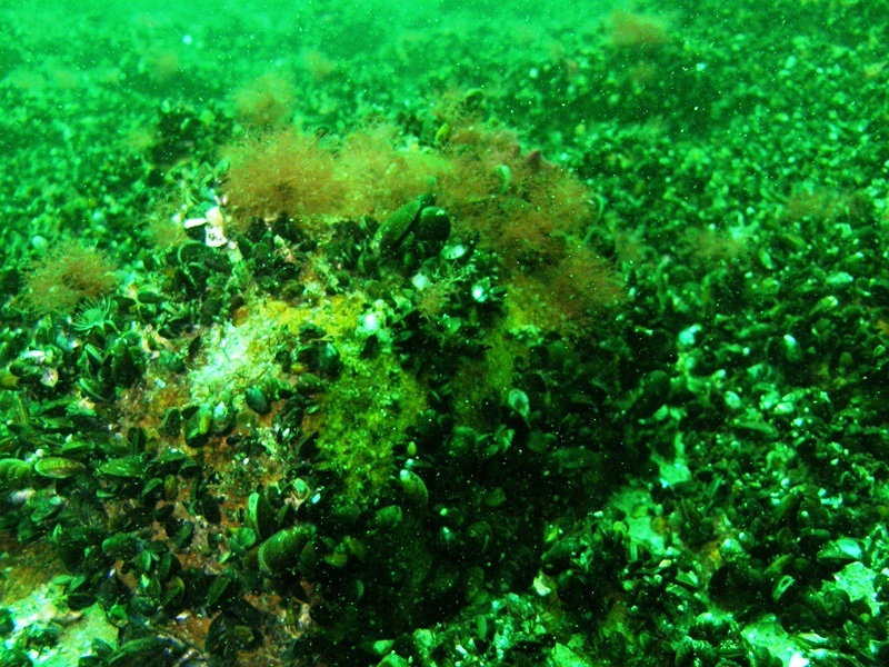
Natural reefs formed as the result of cliff erosion are situated at the depth of 1-8 m (site central point: 18°34,273’E; 54°29,093’N). Reefs are overgrown with macroalgae, mainly green algae Ulva and Cladophora down to the depth of 2 m, in deeper zone with red algae Polysiphonia fucoides. Hard bottom is in some places overgrown with brown algae Protohalopteris radicans that rarely noted in the Polish marine waters and by protected species of red algae Furcellaria lumbricalis (Kruk-Dowgiałło et al. 2009, SEM 2000-2015). Zoobenthos communities of hard bottom (blue mussels, barnacles, bryozoans) are accompanied by numerous small crustaceans (Osowiecki and Żmudziński 2000, Kruk-Dowgiałło et al. 2009).
In the vicinity of natural reefs, three underwater breakwaters were built (each approx. 70 m long). They are made of natural stones and unlike the stones naturally distributed on the bottom, they form a compact spatial structure located at depth of 3 m (site central point 18°34,163’E; 54°28,997’N). The breakwaters cover an area of 0.39 ha (Kruk-Dowgiałło et al. 2009). According to the Habitats Directive of European Union, underwater breakwaters can be regarded as artificial reefs (Interpretation manual 2013), where developed macroalgae communities prevent eutrophication, serve as a source of oxygen, food for herbivores and constitute a substrate for spawning and shelter for fish. Monitoring studies carried out on the breakwaters surface in 2007-2009 (Brzeska et al. 2009) showed that developed communities of flora and fauna are similar to those on natural reefs.
The outstanding natural values of reefs near Orłowo Cliff were noticed in 1992, when zoobenthos research stared and next when it was continued in 1996 and 1997, but additionally included phytobenthos (Osowiecki and Żmudziński 2000). Proposal to cover the site with reserve protection together with detailed description of borders and natural values of the area was sent to the Ministry of Environment in 1998 (Czeczatka et al.1998, Osowiecki and Żmudziński 2000). Since 2000, the monitoring studies of phytobenthos has been carried out on natural reefs within the framework of the State Environmental Monitoring programme in Poland.
In 2016, the Maritime Institute in Gdańsk conducted environmental studies in the habitat 1170 allowing its status assessment. Studies were supported by project ”Pilot monitoring studies of marine habitats and protected species in 2015-2018”.
Literature
- Andrulewicz E., Kruk-Dowgiałło L., Osowiecki A. 2004. Phytobenthos and macrozoobenthos of the Slupsk Bank stony reefs, Baltic Sea. Hydrobiologia 514 (1): 163–170.
- Mapowanie zasięgu występowania makroglonów w północno-zachodniej części Ławicy Słupskiej oraz strefy przybrzeżnej pomiędzy Stilo a Ustką w kontekście planowania przestrzennego polskich obszarów morskich. Praca wykonana w ramach środków finansowych przyznanych na działalność statutową decyzją Ministra Nauki i Szkolnictwa Wyższego nr 611/E-272/S/2009-1, p. 30.
- Brzeska P., Michałek-Pogorzelska M., Opioła R., Błeńska M., Kuliński M., Kruk-Dowgiałło L., Osowiecki A. 2009.
- Badania biologiczne progów podwodnych w Gdyni-Orłowie (trzecia seria). Ekspertyza wykonana na zlecenie Urzędu Morskiego w Gdyni. WW IM w Gdańsku Nr 6482, p. 37.
- Czeczatka M., Opioła R., Osowiecki A., Żmudziński L. 1998.
- Opracowanie dokumentacji przyrodniczej uzasadniającej utworzenie rezerwatu morskiego przy klifie Orłowskim oraz wstępne oraz wstępne rozpoznanie walorów biocenotycznych wzdłuż zewnętrznej strony Mierzei Helskiej, Gdynia Centrum Biologii Morza PAN.
- Demel K., Mańkowski W. 1951. Quantitative investigations on the bottom fauna in the southern Baltic. Pr. Mor. Inst. Ryb., Gdynia 6: 58–82.
- Demel K., Mulicki Z. 1954. Quantitative investigations on the biological bottom productivity in the southern Baltic. Pr. Mor. Inst. Ryb., Gdynia 7: 75–126.
- Interpretation manual of European Union Habitats 2013. EUROPEAN COMMISSION DG ENVIRONMENT Nature ENV B.3, EUR 28, April 2013, p. 144.
- Kruk-Dowgiałło L. (ed.) 2000. Przyrodnicza waloryzacja morskich części obszarów chronionych HELCOM BSPA województwa pomorskiego. Vol. 1. Slowiński Park Narodowy. CRANGON 5, CBM PAN Gdynia, ISBN 83-906449-3-2, p. 116.
- Kruk-Dowgiałło L., Brzeska P., Błeńska M., Opioła R., Kuliński M., Osowiecki A. 2009.
- Czy ochrona brzegów niszczy siedliska denne? Studium przypadku – progi podwodne w Gdyni Orłowie. [in:] Monografie PAN Nr 60. Polska Inżynieria Środowiska pięć lat po wstąpieniu do Unii Europejskiej, Vol 3. Lublin 2009: 125–136.
- Kruk-Dowgiałło L., Kramarska R., Gajewski J. (eds) 2011.
- Siedliska przyrodnicze polskiej strefy Bałtyku: Głazowisko Ławicy Słupskiej. Instytut Morski w Gdańsku, Państwowy Instytut Geologiczny – Państwowy Instytut Badawczy. Gdańsk – Warszawa, ISBN 978-83-62438-09-9, p. 43 + 14 maps (maps 2, 3, 4 in scale 1:25 000; 1, 5–14 in scale 1:50 000).
- Kruk-Dowgiałło L., Osowiecki A., Opioła R., Brzeska P., Błeńska M. 2008.
- Badania biologiczne oceniające stan biocenoz dennych w strefie przybrzeżnej środkowego wybrzeża w rejonie Rowów. W ramach projektu badawczego MNiSW (N306296933). WW IM w Gdańsku nr 6425, p. 30.
- Okołowicz G. 1991. Benthos of the Słupsk Bank and the Gulf of Gdańsk. Acta Ichty. Et Piscatoria. XXI Supplement, Szczecin: 171-179.
- Osowiecki A., Kruk-Dowgiałło L. (eds) 2006 a. Różnorodność biologiczna przybrzeżnego głazowiska Rowy przy Słowińskim Parku Narodowym. Zakład Wydawnictw Naukowych IM w Gdańsku, Gdańsk, ISBN 83-85780-80-7, p. 127
- Osowiecki A., Kruk-Dowgiałło L. 2006 b. Techniki zdalnej detekcji w badaniach różnorodności biologicznej, siedlisk dna morskiego i oceny zasiedlających je zasobów flory i fauny. [in:] Postęp w Inżynierii Środowiska, (ed.) Tomaszek J. IV Ogólnopolska konferencja naukowo-techniczna, Rzeszów – Bystre k/Baligrodu 21-23.09.2006. Wyd. Oficyna Wyd. Politechniki Rzeszowskiej, ISBN 83-7199-397-8: 465-475.
- Osowiecki A., Kruk-Dowgiałło L. 2007. Applying combined biological methods with remote sensing techniques in studies of marine biodiversity, bottom habitats and communities of flora and fauna. Environment Protection Engineering. No 2, Wrocław: 193-205.
- Osowiecki A., Żmudziński L. (eds.) 2000.
- Przyrodnicza waloryzacja morskich części obszarów chronionych HELCOM BSPA województwa pomorskiego. Tom 2. Rezerwat Przyrody Kępa Redłowska. CRANGON 6, CBM PAN Gdynia, ISBN 83-906449-4-0, p. 80.
- SEM 2000-2015. Data collected within the State Monitoring Programme in Poland in 2000-2015.
- SEM 2008-2015. Data collected within the State Monitoring Programme in Poland in 2008-2015.
- SEM 2010-2015. Data collected within the State Monitoring Programme in Poland in 2010-2015.
- Regulation of the Minister of Environment on 9 Oct 2014 about the protection of plant species (Journal of Laws 2014 pos. 1409).
- SDF for PLC990001. Standard Data Form for PLC990001 Słupsk Bank, 10.2013.
- SDF for PLH220023. Standard Data Form for PLH220023 Ostoja Słowińska, 02.2014.
- SDF for PLH220105. Standard Data Form for PLH220105 Orłowo cliffs and reefs, 10.2013.
- Warzocha J. 1980.
- Wstępne badania makrozoobentosu Ławicy Słupskiej. Bull. Sea Fish. Inst. 5-6/61-62: 23–25.
- Warzocha J. 2004.
- Skaliste i kamieniste dno morskie (rafy). [in:] J. Herbich (ed.) Siedliska morskie i przybrzeżne, nadmorskie i śródlądowe solniska i wydmy. Poradniki ochrony siedlisk i gatunków Natura 2000 – podręcznik metodyczny. Ministerstwo Środowiska, Warszawa, vol. 1: 61–64